
A Devon Wildlife Trust Nature Reserve
Woodland walks give way to stunning estuary views on the edge of Plymouth.
https://www.devonwildlifetrust.org/nature-reserves/warleigh-point
- Hits: 1294
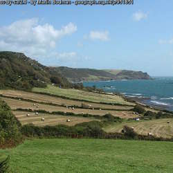
This landscape of elevated coastal plateau rises gently towards the coast affording distinctive views inland across and down the Salcombe to Kingsbridge Estuary and as far as Dartmoor. It drops abruptly into the sea with dramatic cliffs forming a spectacular rugged coastline; and between Prawle Point and Start Point raised beaches (some of which are farmed) are a defining feature revealing the effects of past coastal erosion during time of higher sea levels. Above the cliffs areas of colourful bracken, gorse and blackthorn often occur, providing important habitat for birds including cirl bunting. Although it appears relatively uniform in height, the plateau is incised by coastal combes containing small streams and the upper reaches of tributaries to the Salcombe to Kingsbridge Estuary. Along the coast this landscape has an ‘edge of the world’ feel, offering exhilarating walks and a strong sense of tranquillity and isolation.
This area comprises an elevated coastal plateau and rugged coastline running east-west from Bolt Tail to Start Point and flanks the southern reaches of the Salcombe to Kingsbridge Estuary. To the south, east and west the landscape is fringed by the sea and to the north the boundary of this area is marked by a transition to a slightly lower lying inland plateau landscape which is less influenced by the coast.
https://www.devon.gov.uk/planning/south-hams-area/bolt-tail-and-start-point-coastal-plateau
https://www.devon.gov.uk/planning/planning-policies/landscape/devon-character-areas
- Hits: 1229
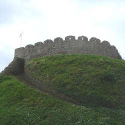
A classic Norman motte and bailey castle, founded soon after the Conquest to overawe the Saxon town. A later stone shell-keep crowns its steep mound, giving sweeping views across the town rooftops to the River Dart.
Climb to the top of the keep to enjoy stunning views over the town of Totnes and across to the River Dart. Or enjoy a picnic in the peaceful grounds under the shelter of age old trees - there is plenty of space for families to relax on a summers day. Within easy walking distance of the town, the castle is an ideal addition to any day out in South Devon and you can combine the visit with one to nearby Dartmouth and Berry Pomeroy Castles which are just a short drive away.
https://www.english-heritage.org.uk/visit/places/totnes-castle/
Totnes Castle Castle Street, Totnes TQ9 5NU
- Hits: 1210
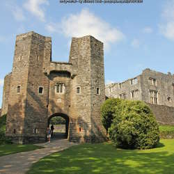
Tucked away in a deep wooded valley, Berry Pomeroy Castle is the perfect romantic ruin with a colourful history of intrigue.
Within the 15th-century defences of the Pomeroy family castle, looms the dramatic ruined shell of its successor, the great Elizabethan mansion of the Seymours. Begun in around 1560 and ambitiously enlarged from around 1600, their mansion was intended to become the most spectacular house in Devon, a match for Longleat and Audley End. Never completed, and abandoned by 1700, it became the focus of blood-curdling ghost stories, recounted in the audio tour.
The location of the castle makes it ideal for walkers who can explore the nearby beautiful woodland or you can enjoy a light lunch, home made cake or restorative cup of tea in the cafe. Within a short drive are Totnes Castle and Dartmouth Castle, making it an ideal day out for families.
https://www.english-heritage.org.uk/visit/places/berry-pomeroy-castle/
Berry Pomeroy Castle Berry Pomeroy, nr Totnes TQ9 6LJ
Social Media:
Facebook: https://www.facebook.com/berrypomeroycastle/
- Hits: 1275
Some 300 Bronze Age and medieval sites, covering 15.5 square kilometres (6 square miles) of Dartmoor landscape.
Today the Upper Plym Valley is a typically treeless Dartmoor landscape, grazed by cattle, sheep and ponies. It is hard to imagine it 3,500 years ago dotted with settlements of neat round huts, with fields of crops growing near the river and herds of pasturing animals on the higher slopes; or, in medieval and later times, alive with the activity of rabbit farming and tin streaming.
The Upper Plym Valley has an extraordinary concentration of stone remains littered across an area of 15.5 square kilometres (6 square miles), making it one of the richest archaeological landscapes of Dartmoor. The area extends from the source of the River Plym down to the china clay pits at Lee Moor, a distance of some 7 kilometres (4.5 miles).
The remarkable survival of so many sites is due largely to the lack of agricultural or industrial activity on the moor in modern times, which has meant that many of the prehistoric and later monuments have been left undisturbed.
Most of the remains belong either to the Bronze Age (about 2300–700 BC) or the Middle Ages. Some indication of the level of activity that once took place here was provided by an archaeological field survey undertaken between 2001 and 2002, when more than 300 monuments dating chiefly from these two periods were recorded.
https://www.english-heritage.org.uk/visit/places/upper-plym-valley/
Upper Plym Valley Dartmoor PL7 5EJ
- Hits: 1152
One of the most beautifully located fortresses in England. For over 600 years Dartmouth Castle has guarded the narrow entrance to the Dart Estuary and the busy, vibrant port of Dartmouth. It offers stunning views of the estuary and out to sea and offers a great family day out, whatever the weather.
This fascinating complex of defences was begun in 1388 by John Hawley, privateering Mayor of Dartmouth and the prototype of the flamboyant 'Shipman' in Chaucer's Canterbury Tales. About a century later the townsmen added the imposing and well-preserved 'gun tower', probably the very first fortification in Britain purpose-built to mount 'ship-sinking' heavy cannon. Climb to the top for breathtaking views across the estuary and see how it could be blocked in wartime by a heavy chain.
Unusually incorporating the fine church of St Petrox, the castle saw action during the Civil War, and continued in service right up until the Second World War. Successive up-dating included the Victorian 'Old Battery' with its remounted heavy guns, guardrooms and maze of passages to explore.
https://www.english-heritage.org.uk/visit/places/dartmouth-castle/
Dartmouth Castle Castle Road, Dartmouth, Devon, TQ6 0JN
- Hits: 1106
This Tudor fort, built by the borough of Dartmouth between 1522 and 1536, contained heavy guns to protect the prosperous harbour town from attack. It was the last line of defence against enemy ships that had eluded Dartmouth and Kingswear castles and the iron chain stretched across the Dart estuary between them. Occupying a terrace cut from the rocky river bank, Bayard’s Cove Fort is picturesquely sited at the entrance to Dartmouth harbour.
https://www.english-heritage.org.uk/visit/places/bayards-cove-fort/
Bayard's Cove Fort Bayards Cove, Dartmouth, Devon, TQ6 9AX
- Hits: 1143
The Torbay Hinterland is a steeply undulating series of hills incised by small streams which extend into the adjacent urban areas. It includes a distinctive rim of landscape which forms the setting and backdrop to Torbay with views across the conurbation out to sea. Here the proximity of the urban edge has resulted in a proliferation of urban fringe development and recreation activities which have fragmented the hedgerow, woodland and land use patterns and made them vulnerable to change. Nevertheless, fingers of green landscape penetrate down the steep valleys into the built up areas of Torbay, creating welcome contrasts and opportunities for recreation. Further west the landscape looks inland, with views to Dartmoor in the west. Here there is a stronger rural character; the folds of the landscape and high hedgebanks lend visual enclosure and a greater degree of tranquillity; the historic pattern of hedgebanks, small woods, winding rural lanes and sparse settlement remains intact; and historic castle sites are a feature that adds to the time depth of the landscape.
The Torbay Hinterland is located adjacent to the coastal resorts of Torbay (Torquay, Paignton and Brixham) and forms a rim of rural landscape that acts as a setting to these settlements, offering views eastwards across the built up area and out to sea. To the west the landscape faces inland and overlooks the tributary valleys of the River Hems. Here the boundary with the Denbury and Kerswell Farmlands is transitional. In contrast the eastern boundary is abrupt and is formed by the urban edge; while to the south the boundary follows the ridge which separates Torbay from the tidal Dart Estuary south-east of Totnes.
https://www.devon.gov.uk/planning/teignbridge-and-east-devon-area/torbay-hinterland
https://www.devon.gov.uk/planning/planning-policies/landscape/devon-character-areas
- Hits: 990
This character area comprises the valley of the River Dart and tributaries, and surrounding rolling hills and slopes. The Dart flows through a winding, frequently wooded, narrow gorge for much of its course, widening to a flood plain and more expansive river with weirs and more gentle slopes, particularly to the north of the river. Its tributaries including the River Hems lie in narrow valleys, enclosed by rounded hills with limited tree cover; the landscape tends to broaden at confluences. Views are obtained across and along the valleys in places, to nearby hills and the rising mass of Dartmoor to the west. However many views are relatively short and contained, focusing on the rounded hills and rivers which give this area its sense of place. The area is strongly defined by the steep, winding, narrow wooded valley of the Dart and to a lesser extent by its tributaries and surrounding rolling hills. There is a strong sense of tranquillity within the rolling hills and valleys away from settlement and transport infrastructure.
This area comprises the River Dart and surrounding slopes and hills between the A38 and the foothills of Dartmoor in the west, and Totnes in the east. It is bounded to the south by a marked change to a distinctive landscape of interlocking rounded ridges and incised valleys and to the north by the elevated farmland of Denbury Down.
https://www.devon.gov.uk/planning/teignbridge-and-east-devon-area/mid-dart-valley-and-slopes
https://www.devon.gov.uk/planning/planning-policies/landscape/devon-character-areas
- Hits: 1157
This is a transitional landscape, linking the upland moor with the lowlands to the south, and forming the backdrop to many views of Dartmoor from the south. It is a landscape of changing colours and textures, with the golds, browns and purples of the moorland contrasting with the vivid greens of the pasture below. Fast-flowing streams rush down the hillsides in steep, narrow valleys which are often clothed in oak woodland. Farms and small villages nestle in valleys or in the folds of the hillsides, surrounded by ancient patterns of fields and linked by a network of twisting sunken lanes. On the moorland there is an extraordinary sense of time-depth, with many abandoned settlements from prehistoric and medieval periods reflecting the ebb and flow of people’s colonisation of the moor.
This area comprises the southern part of Dartmoor and encompasses upland moorland and the south-facing slopes and river valleys below it. The area itself forms a transition from upland to lowland, and its boundaries with surrounding character areas are gradual. It forms a ‘horseshoe’ shape around High Dartmoor South, with Central Dartmoor to the north. To the west is the River Tavy Middle Valley; to the south-west the Plymouth Northern Wooded Slopes; to the south the Plymouth and Modbury Farmland and the Mid Avon Valley and West Dart Valleys and Ridges; and to the east the East Dartmoor Moorland Fringes and the Mid Dart Valley and Slopes.
https://www.devon.gov.uk/planning/planning-policies/landscape/devon-character-areas
- Hits: 1159


