
South West Lakes Trust Lopwell Dam is a beautiful spot at any time of the year; the colours and views on display are simply breathtaking.
Near Plymouth, the Local Nature Reserve is home to a varied range of wildlife, both in and out of the water. Delve into Lopwell’s long history (all the way back to the 13th century!), and learn about how this peaceful haven was once a busy river quay that served Plymouth and London, with a mineshaft used for mining lead and silver.
https://www.swlakestrust.org.uk/lopwell
Lopwell Dam, Plymouth, PL6 7BZ
- Hits: 1590
South West Lakes Trust Near the idyllic village of Chagford, Fernworthy Reservoir is an archaeological jewel in the heart of Dartmoor National Park.
Walk through meadows, woodland and moorland, and take in the fascinating cultural heritage of ancient stone cairns, Bronze Age hut circles and submerged clapper bridges, while enjoying beautiful lakeside views.
https://www.swlakestrust.org.uk/fernworthy
Fernworthy Reservoir, Newton Abbot TQ13 8EA
- Hits: 1217
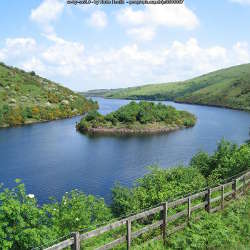
South West Lakes Trust Meldon is situated on Dartmoor National Park, approximately 900 feet above sea level, with stunning views over the Okement Valley.
Explore open moorland, dramatic tors and a Scheduled Monument: boasting a special combination of industrial heritage, wildlife and nature trails, Meldon is the perfect location to enjoy a unique day outdoors.
https://www.swlakestrust.org.uk/meldon
Meldon Reservoir, Okehampton EX20 4LU
- Hits: 1624

Dartmoor National Park Authority was created by the Environment Act 1995 to:
- conserve and enhance Dartmoor National Park’s natural beauty, wildlife and cultural heritage
- promote opportunities for the public to understand and enjoy the special qualities of Dartmoor National Park.
Social Media:
Facebook: https://www.facebook.com/enjoydartmoor1 (16.3k)
Twitter: https://twitter.com/dartmoornpa (18.4k)
Instagram: https://www.instagram.com/lovedartmoor/ (14.7k)
YouTube: https://www.youtube.com/user/DartmoorNPA (1.7k)
Dartmoor Food and Drink Map
https://www.dartmoor.gov.uk/living-and-working/local-food-and-drink-map
- Hits: 1356
Dartmoor is rich in prehistoric remains, and the group of monuments at Merrivale is one of the finest on the moor. Side by side here are the remains of a Bronze Age settlement and a complex of ritual sites, including three stone rows, a stone circle, standing stones and a number of cairns – earth mounds associated with burials. The monuments were probably built over a long period, between about 2500 BC and 1000 BC.
https://www.english-heritage.org.uk/visit/places/merrivale-prehistoric-settlement/
Merrivale Princetown, Yelverton, Devon, PL20 6ST
- Hits: 1064
Beautifully sited on the fringe of Dartmoor, Lydford boasts three defensive features. Near the centre is a 13th century tower on a mound, built as a prison. It later became notorious for harsh punishments, with one of its inmates calling it 'the most annoious, contagious and detestable place within this realm'. To the south is an earlier Norman earthwork castle and to the north, there are Saxon town defences.
https://www.english-heritage.org.uk/visit/places/lydford-castle-and-saxon-town/
Lydford Castle and Saxon Town Lydford EX20 4BH
- Hits: 1005
The remains of the largest castle in Devon, in a stunning setting on a wooded spur above the rushing River Okement. Begun soon after the Norman Conquest as a motte and bailey castle with a stone keep, it was converted into a sumptuous residence in the 14th century by Hugh Courtenay, Earl of Devon, much of whose work survives. After the last Courtenay owner fell foul of Henry VIII in 1539, the castle declined into a ruin.
There is a riverside picnic area and beautiful woodland walks nearby. It's also a great place for bird lovers with regular visiting species and in spring and early summer you can enjoy a variety of seasonal wild flowers, which adorn the meadow, woodland and motte.
https://www.english-heritage.org.uk/visit/places/okehampton-castle/
Okehampton Castle Castle Lodge, Okehampton EX20 1JA
- Hits: 1084
This is a transitional landscape, linking the upland moor with the lowlands to the south, and forming the backdrop to many views of Dartmoor from the south. It is a landscape of changing colours and textures, with the golds, browns and purples of the moorland contrasting with the vivid greens of the pasture below. Fast-flowing streams rush down the hillsides in steep, narrow valleys which are often clothed in oak woodland. Farms and small villages nestle in valleys or in the folds of the hillsides, surrounded by ancient patterns of fields and linked by a network of twisting sunken lanes. On the moorland there is an extraordinary sense of time-depth, with many abandoned settlements from prehistoric and medieval periods reflecting the ebb and flow of people’s colonisation of the moor.
This area comprises the southern part of Dartmoor and encompasses upland moorland and the south-facing slopes and river valleys below it. The area itself forms a transition from upland to lowland, and its boundaries with surrounding character areas are gradual. It forms a ‘horseshoe’ shape around High Dartmoor South, with Central Dartmoor to the north. To the west is the River Tavy Middle Valley; to the south-west the Plymouth Northern Wooded Slopes; to the south the Plymouth and Modbury Farmland and the Mid Avon Valley and West Dart Valleys and Ridges; and to the east the East Dartmoor Moorland Fringes and the Mid Dart Valley and Slopes.
https://www.devon.gov.uk/planning/planning-policies/landscape/devon-character-areas
- Hits: 1125
This extensive area of remote and wild land contains the highest land in Dartmoor, rising to 621m at High Willhays. Large expanses of blanket bog, heather and grass moorland form broad, uninterrupted skylines broken only by the occasional tor or rock outcrop. The landscape is crossed by a network of streams and valley mires, with thick deposits of peat and blanket bogs which form the sources of many of the major rivers of Devon including the Dart, Teign and Taw. The high levels of tranquillity and remoteness are occasionally interrupted by sounds relating to the long-standing military use of the moor. The strong time-depth of the landscape is reflected in a rich archaeological resource of human activity over many millennia. The high, open moorland affords expansive and panoramic views across the surrounding lower landscapes within the National Park and as far beyond as Exmoor.
This area comprises the unsettled northern parts of High Dartmoor, north of the Dart valley and south of Okehampton. It contains some of the most remote and elevated landscapes within Dartmoor National Park. To the south and east is a gradual transition to Central Dartmoor, and to the west to the Tavistock Dartmoor Fringes. To the north is a more abrupt boundary with the Moretonhamptead Moorland Fringes and the Upper Tamar Tributary Valleys, marked by the change from open moorland to enclosed fields.
https://www.devon.gov.uk/planning/planning-policies/landscape/dartmoor-area/high-dartmoor-north
https://www.devon.gov.uk/planning/planning-policies/landscape/devon-character-areas
- Hits: 1144
This is a high, wild, bleak and evocative landscape which forms the skyline to many views within and beyond Dartmoor National Park to the south, west and east. Although smaller in extent than High Dartmoor North, it can feel even more remote from significant areas of settlement. It is covered in extensive areas of blanket bog and mire which form the sources of many of South Devon’s rivers. The landscape is devoid of modern settlement, roads or other features, yet presents a rich archaeological heritage in the forms of prehistoric ceremonial sites and settlements, and later evidence of mining activity, peat extraction and clay working. It is a landscape which is highly valued for its nature conservation importance, and also for its vital role as a water catchment. In this exposed landscape, the weather has a strong influence on the sense of place, ranging from all-encompassing rain and mist to clear skies, strong colours and outstanding views across south Devon to the sea.
This area comprises the highest land to the south of the Dart valley and forms an upland plateau covered by blanket bog. At the edges of the area there is a gradual transition into the surrounding character areas of Central Dartmoor to the north, and Southern Dartmoor and Fringes to the south.
https://www.devon.gov.uk/planning/planning-policies/landscape/dartmoor-area/high-dartmoor-south
https://www.devon.gov.uk/planning/planning-policies/landscape/devon-character-areas
- Hits: 1084


