
The Devon Redlands National Character Area (NCA) has a very strong, unified character. The underlying red sandstone and consequent red soil dominate the landscape through ploughed fields, cliffs and exposures, and are visually evident in the traditional stone and cob farmsteads, hamlets and villages that are scattered across the area. Not only does the soil visually characterise the area but its fertility also makes it the agricultural heart of Devon. Mixed agriculture has shaped this landscape since medieval times, an era that left a dense pattern of deep and narrow lanes imprinted in the landscape. The gently rolling hills that feature across the NCA support a network of hedgerows enclosing relatively small fields that are either grazed or under arable cultivation. Hedgerow trees and small copses often give a wooded appearance to the hills. The valleys in between are flat bottomed and open into extensive flood plains across the central part of the Redlands. Here, more ‘shrubby’ hedgerows or fences enclose larger arable or grazed fields.
http://publications.naturalengland.org.uk/publication/6150022?category=587130
Rivers have created the topography that we see today and they remain as key landscape features. The core of the Devon Redlands is low lying, with land rising around the periphery, except to the south where it gives way to the coast. Consequently, most of the rivers rise in higher, adjoining NCAs and flow from north to south to the coast, often through estuaries that are internationally and nationally important for wildlife. The coastal strip of this NCA, now partially inscribed as a World Heritage Site for its natural attributes, has significant Victorian influence, with railways, promenades and piers for seaside visitors. The area is still a popular visitor destination with access along the coast facilitated by the South West Coast Path National Trail.
Land in the west of the NCA rises to the flat, flint-topped Haldon Hills, now mainly under coniferous plantation with some remnant lowland heath. These hills form a prominent landscape feature which is visible across the Redlands and beyond. They provide a distinctive landscape setting for the Roman city of Exeter, now a regional centre with a significant amount of planned growth to the east. The character of this part of the NCA is fast changing. Land in the east of the NCA rises to the East Devon Pebblebed Heaths, an area of extensive open access lowland heath, designated as a Site of Special Scientific Interest and part of the East Devon Area of Outstanding Natural Beauty.
Statements of Environmental Opportunities:
- SEO 1: Protect and manage the value and integrity of the coastal and estuarine landscape with its diversity of cliffs, geology, geomorphology, historic features, habitats and associated wildlife, contributing to the livelihoods, enjoyment and education of people.
- SEO 2: Manage, enhance and where necessary protect the diversity of land use and activity which gives the Devon Redlands its distinctive character. Increase the connectivity of key habitats for the benefit of landscape, biodiversity and ecosystem services.
- SEO 3: Protect and manage the distinctive character of the landscape, the natural beauty, scenic quality, historic environment and geological features. Enhance recreational resources, access to nature and heritage assets, particularly along the coast, to ensure public benefit and enjoyment.
- SEO 4: Plan and manage for a strong landscape framework to support and integrate the expansion of Exeter, Exmouth, Teignmouth, Tiverton, Crediton and Cullompton, and the road and rail network throughout the area. Conserve and enhance the existing character, form and pattern of the area’s historic settlement, from single farmsteads to larger villages.
https://commons.wikimedia.org/wiki/File:Cliffs_near_Dawlish_(7253).jpg
Ecosystem Services
The Devon Redlands NCA provides a wide range of benefits to society. Each is derived from the attributes and processes (both natural and cultural features) within the area. These benefits are known collectively as ‘ecosystem services’. The predominant services are summarised below.
Provisioning services (food, fibre and water supply)
Food provision: The NCA is a major food-producing area for the county and the region. The levels and type of food produced reflect soil productivity, favourable climatic conditions and availability of water. Approximately half of all farm holdings are classified as livestock in terms of their farming type, and the remaining holdings support, dairy, arable, horticulture and mixed farming, with a relatively few specialist pig producers. Between 2000 and 2009 there was an increase in the number of arable and horticultural holdings, 14% in number, and a decrease in the number of all other farming types, possibly in response to market prices. The NCA is also showing a minor resurgence in apple production for ciders and apple juices. The estuaries are also significant for their food production: the Exe Estuary supports three commercial shellfish fisheries and the Teign produced shellfish to the value of £171,000 in 2004. Both estuaries have designated bass nursery areas and are important spawning grounds for salmon.
Timber provision: Commercial timber production is currently focused on the conifer plantations of the Haldon Hills and on the edge of Woodbury Common, covering 3 per cent of the NCA, and the mixed woodlands of Ashclyst Forest. Most extraction from Ashclyst in recent years has been for firewood in response to rising demand.
Water availability: Water is abstracted throughout the catchments of the Exe and Otter, from the rivers and from the Otter Valley Aquifer. Water flows in the Exe are maintained by the release of water from Wimbleball Reservoir in the adjoining Exmoor NCA. Water is used most significantly for public supply and agriculture within the NCA. Apart from some private abstraction there is no other water supply to the area east of the Haldon Hills. West of the Haldon Hills public supply is from the rivers of the Teign catchment.
Regulating services (water purification, air quality maintenance and climate regulation)
Climate regulation: Limited climate regulation is offered by the shallow but more carbon-rich soils of the East Devon Pebblebed Heaths and the Haldon Heaths (a combined area of less than 10 per cent of the NCA) and by woodland cover and its underlying humus-rich soils, covering 10 per cent of the area. Carbon storage is also provided by the wetlands, notably the grazing marsh (currently covering over 5,000 ha), and the silt-rich muds of the estuaries which are high in organic matter, although subject to high levels of flux.
Regulating water quality: The priority catchments of the Exe and Otter suffer from diffuse water pollution as a result of soil erosion, slurry run-off from intensive dairy farms, and high levels of phosphates and nitrates in rivers, particularly attributable to areas of maize cropping and compacted grassland. River water quality is judged to be of only moderate ecological quality in most of the main rivers (the rivers Exe and Culm) with areas of good quality in the west (the rivers Yeo and Teign) and poor quality in the east (the River Otter). The chemical status of groundwater is also classified as poor.
Regulating water flow (flooding): Steep slopes and high rainfall, especially in the upper catchment of the River Exe, rising on Exmoor, mean that river levels can rise quickly following rainfall and flooding is a frequent characteristic of the lower Exe, Clyst and Otter. This underlines the vital importance of the broad flood plains of the major rivers of the area in storing and regulating flood flows. Exeter is at risk of flooding from the Exe and Clyst rivers, Tiverton is at risk from the Exe and Ottery St Mary is at risk on the Otter. Climate change is likely to exacerbate this problem, and the Exe Catchment Flood Management Plan identifies that further action should be taken to reduce the risks, including through the storage of water and management of run-off in the headwaters of the Exe and Culm, partly outside this NCA, to alleviate downstream flooding at Exeter, Tiverton and Cullompton (on the Culm) while also benefiting Biodiversity Action Plan habitats and species.
Regulating soil erosion: The catchments of the Exe and Otter are priority catchments under the Catchment Sensitive Farming Project. Soil erosion is a specific issue across the area and within these catchments, particularly attributable to areas of maize cropping and the regular cultivation of soils on steeper slopes (arable cropping and to a lesser extent ley grasslands). Run-off and soil wash from improved grassland is also an issue in the Exe and Otter catchments.
Coastal flooding: Localised coastal flooding occurs along the shores of the Exe Estuary and at the mouth of the Teign and Otter, although this does not currently affect property. Nevertheless, settlements to the west of the Exe Estuary (Exminster, Starcross and Cockwood) and the coastal towns of Exmouth, Budleigh Salterton and Sidmouth, as well as Teignmouth and Dawlish and the main London to Penzance railway line which follows the coast west of Exeter, may be subject to increasing inundation, especially in times of storm surge, as a result of an eroding coastline and rising sea levels. Strategies of ‘Hold the Line’ are still largely identified as the current practical option for much of the coastline, including around Budleigh Salterton, Exmouth and stretches south of Dawlish Warren. Managed realignment options are already being considered for parts of the coastline – including the option for possible extension of intertidal habitats north of Powderham Bank associated with the River Clyst if some defences are allowed to fail at Dawlish Warren (as part of the Exe Estuary Coastal Management Study, 2008).
Cultural services (inspiration, education and wellbeing)
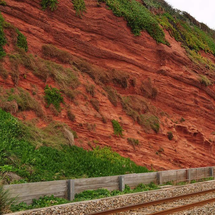
Sense of place/inspiration: The landscape has a strong sense of place and an overriding spontaneous affinity with farmland, rolling fields and hedgerows, and a ‘rural’ look. The underlying red sandstone is a defining characteristic for much of the area, resulting in the prominent red soil, many red-tinged buildings and striking coastal features. The defining characteristics that are valued most strongly include: the dense network of sunken winding lanes with high, flower-covered banks that contribute to a sense of tranquillity; fields of different shapes and sizes surrounded by Devon hedgebanks; rural buildings with thatched roofs, some with cob walls, and some with red building stone; the villages; and a rural lifestyle. The coast with its striking red cliffs and stacks is visually and geologically different from the coastline to the west and east. The geological significance of the area is recognised by World Heritage Site status from Exmouth eastwards. The long sandy beaches and adjoining promenades reflect Victorian tourism that lives on today. The estuaries contribute to the area’s sense of place and create a zone of maritime influence inland. The Exe, an estuary of significant size and international importance, extends its influence into the heart of Exeter.
Sense of history: The landscape is clearly rooted in the past with Mesolithic and Neolithic sites across the area, and it is firmly shaped by a medieval pattern of isolated farmhouses, hamlets and enclosed fields. Most settlements were in existence by the 10th and 11th centuries. Roman influence is evident, particularly around Exeter, and the church has played a significant role in the development of the area, especially around Crediton. Designed landscapes feature across the NCA and today often provide considerable recreational opportunities.
Tranquillity: Although the landscape is perceived to have a strongly rural character, it is not seen as particularly tranquil, a perception that is borne out by the Campaign to Protect Rural England Intrusion Map 2007 which identifies 6 per cent of the NCA as urban, 58 per cent as disturbed and 36 per cent as undisturbed. The lowest scores for tranquillity are associated with the urban centres of Exeter, Teignmouth, Crediton and Tiverton, along with the M5 and other major road corridors, while the highest scores for tranquillity are found in the rural areas, particularly in the north of the NCA (bordering the Blackdown Hills) and the countryside north of Budleigh Salterton. These areas of higher tranquillity correlate with the two designated AONB.
Recreation: The landscape has strong associations with recreation, leisure and touring, with good access to facilities, and villages that offer pubs and cream teas. Active recreation is particularly associated with the coast and the South West Coast Path National Trail, and with the estuaries of the Exe and Teign with their extensive shallow water moorings. In recent years there has been significant growth in cycling with a major mountain biking venue on Haldon. In 2006/07 visitor numbers on Haldon were 80,000, but by 2011/12 this had increased to 220,000. The National Cycle Network (Route 2) follows the coast around this NCA, taking in the fringes of the Teign and Exe estuaries. The off-road sections of this route are proving particularly popular for leisure use. The East Devon Pebblebed Heaths provide a significant area (1,100 ha) of open access which is well used by local residents. There are over 700 km of rights of way (at a density of 0.73 km/ km2), nearly 4,000 ha of open access/common land and 43 km of the South West Coast Path within this NCA.
Biodiversity: There is a range of habitats, from internationally designated estuaries, sand dunes and lowland heath to nationally designated coniferous forest. Hedgerows, woodlands (both mixed and ancient broadleaved), rivers with associated wet habitats and low-input grassland all contribute to the mosaic of habitats supporting an array of species. Bats, including the greater horseshoe, are known to have strategic flyways across the area and roost in the west of the NCA. Other notable species across the area include breeding populations of nightjar, the Dartford warbler, cirl bunting, southern damselfly and the unique warren crocus.
Geodiversity: The geological significance of the coast is recognised by World Heritage Site status from Exmouth eastwards. The geology and geomorphology across this area allow for the study and interpretation of earth sciences up to the earliest occupation of the landscape by man. The alternating periods of marine incursion and mountain building, including volcanic activity, can be observed in both the topography of the area and the coastal and inland exposures (cliffs, quarries and road cuttings). More recent coastal geomorphological features include sand and shingle spits and beaches.


.jpg)